There seems to be a lot of chatter lately about something called "DMC." Something having to do with taxes, I guess. Or new Adidas sneakers.

But in reality, Destination Medical Center is moving forward at breakneck pace. There are RFPs out for major (emphasis on major) consultant contracts to begin the process of planning and shaping the DMC initiative as well as future growth of downtown Rochester.
Complementing (hopefully) those plans, are the requisite public infrastructure investments that will be necessary to support future expansion and growth of Mayo Clinic. This has been repeated many times by politicians and Mayo Clinic officials; to set the stage for growth, certain public components need to be further developed and reinforced to properly support private investment. And as the City of Rochester is the de facto bookkeeper on those public investments they need to begin rolling out projects. All the while being mindful that the projects should always be in accord with the vision and spirit of DMC.
So walk with us down this path and see how we might envision a large scale public project that would support the goal of a walkable and vibrant downtown and enable Mayo Clinic to recruit the best and brightest talent and become the premier global destination for health and healing.
Let's start with what we know:
- The Rochester Downtown Master Plan was created and adopted by the city in 2010. Within the document are myriad recommendations throughout downtown for open space, mobility, and private development.
- The Mayo Clinic 5 Year Master Plan Update was most recently created and adopted in 2011. Within that document are comprehensive outlines of all Rochester-wide Mayo Clinic facilities, land use, and infrastructure and what the future 5 years has in store for related projects (as required by their governing zoning ordinance).
- It is the stated goal of Destination Medical Center to provide the ideal patient, companion, visitor and citizen experience to become the world’s premier destination medical community.
Now where shall we begin?
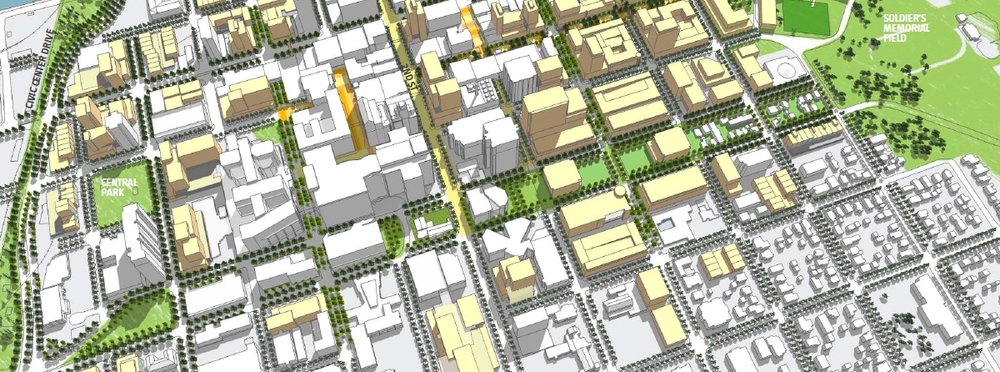
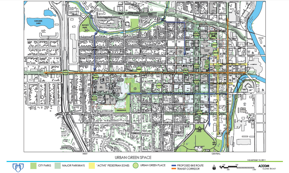
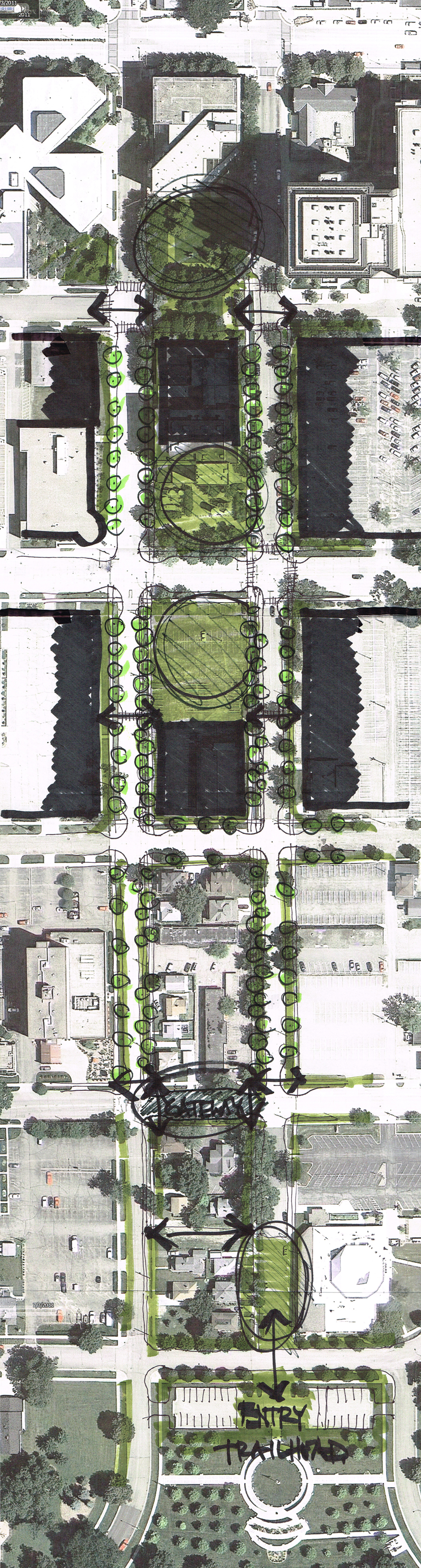
How about we start with a vision that is widely agreed upon by the above referenced documents for a portion of Mayo Clinic's downtown campus. In particular, the one-way streets of 3rd Avenue W and 4th Avenue W. These pair of one-ways (3rd Avenue runs north, 4th Avenue runs south) are an anomaly in our downtown grid. For some reason they create a block that is about half the width of the typical downtown block and facilitate traffic flow from Civic Center Drive to the north all the way to 6th Street SW. North of 2nd Street SW, these one-way pairs book-end several multi-story parking garages and adjacent hotels. South of 2nd Street SW the buildings are much older and vestiges of a land use pattern long since abandoned (evidenced by 2 blocks of single family detached houses). It is this zone, between 2nd Street SW and Soldiers Field Park where we will focus our energy and see where major changes in the street landscape can foster the character of urban design displayed on the pages of both the RDMP and Mayo Clinic Master Plan.
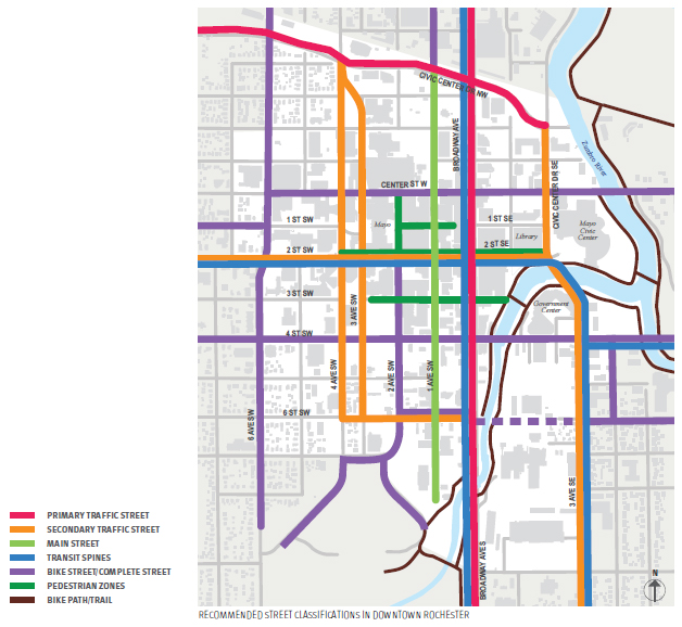
At the heart of any transformative change will be a greater understanding of how these streets function. It is obvious that they are necessary for vehicular traffic. There is a significant outpatient clinic building (Baldwin) on the corner of 2nd Street SW and 4th Avenue SW that accommodates a tremendous amount of automobile traffic. Similarly, the 200 & 300 block of 3rd Ave SW is used as a queuing location for the commuter buses that travel in and out of Rochester on a daily basis. Not to say that this activity couldn't happen someplace else, but it highlights that 2nd Street SW is the epicenter of activity for these one-way pairs with visitors travelling from Civic Center Drive south to 2nd Street SW as well. Even the RDMP indicates these as Secondary Traffic Streets--with the qualifier that it "serves an important function for motor vehicles accessing downtown destinations and parking facilities, but auto movement is necessarily balanced with other priorities."
We believe these "other priorities" are transit, pedestrian, and in particular bicycle traffic. It is the essence of a Complete Street. But in order to create a walkable pedestrian environment in this corridor, more has to be done to make these streets safe, comfortable and inviting. And we believe that to achieve this will require a wholesale change in how we design the one-way pairs. We should aim to transform them from 4 lanes (2 thru-traffic, 2 parking) in each direction to only 3 and increase the pedestrian zone. This road diet can have two primary benefits: 1) slow traffic through the corridor to promote ease of pedestrian crossings and 2) free up space for landscaping and a separated bicycle way.
Before we get into the design details, let's make sure we are being consistent with the planning documents. First of all the Downtown Bicycle Study (adopted 2009) and included in the ROCOG 2040 Long-Range Transportation Plan (adopted 2010) recommends to "develop 3rd & 4th Ave SW with single directional bike lane or diagonally striped wide curb lane."
[CHECK]
Below are images from the RDMP. It sure appears that within what is called the Education and Research District there is a vision for a campus quad-esque landscape with a mixture of flanking multi-story buildings and open relief.
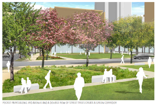
"Future development and public infrastructure investments in the Research Partnership Corridor along 3rd and 4th Avenues create a linear park and green boulevard environment between Civic Center Drive to the North and Soldiers Memorial Field to the South. The central green boulevard is flanked by six to eight story buildings that mix research uses with commercial space...The boulevard is planted with double row of large canopy trees, and interrupted with small pocket parks that span from 3rd to 4th Avenues wherever development needs allow. Buildings have a small setback from the curb to create a lawn and contribute to the sense of an open, campus landscape. The lush, green atmosphere of the corridor provides the city with much needed "breathing room" from the density of Mayo's core to the north, and transitions people down to the open landscape of Soldier's Memorial Field."
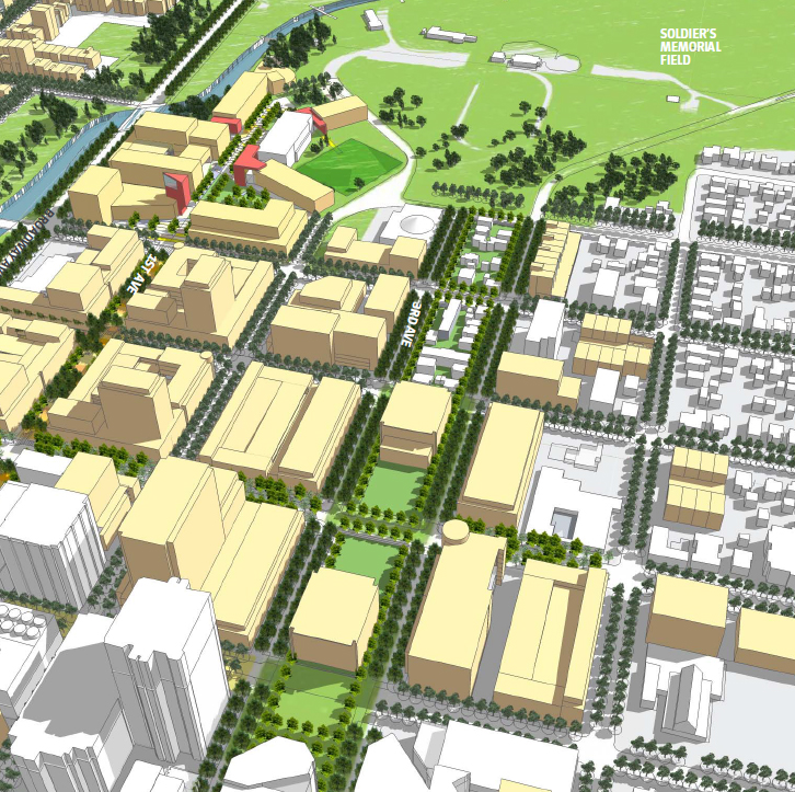
The renderings showcase how a wider pedestrian zone (at the expense of a traffic lane as we are positing) that has two rows of boulevard trees can "breathe" a little and create pocket parks similar to the widely used sunken Harwick Plaza directly south of the Guggenheim & Hilton Buildings.
[CHECK]
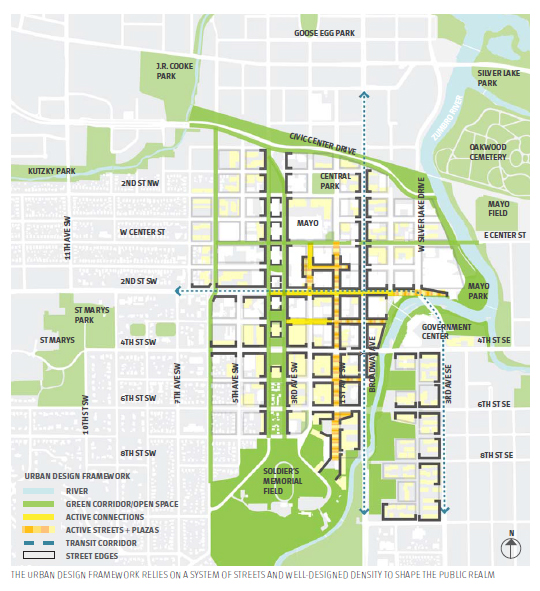
The Mayo Clinic Master Plan Update reiterates the same imagery. Even though they too recognize the significance of this corridor as necessary for car circulation elsewhere in their planning document, they also view it as a beautiful "parkway" spanning from Soldiers Field to Civic Center Drive including a urban green place at 6th Street SW as a South Gateway. (click the image below to enlarge)
[CHECK]
These plans are consistent, and they require bold action on behalf of our public sector. We can take cues from other cities around the country that have removed traffic lanes or in some cases completely eliminated cars from streets to enhance and promote pedestrian access. The Mayo Clinic Gonda Building is a mere six blocks from Soldiers Field Park (including two sizeable children's playgrounds), so why aren't more visitors and patients seen exploring and enjoying our parks system with their families? At the Gonda Building where might a visitor or patient be directed to get access to our extensive trail system? These are important questions to answer if we drill down deeper into the visions of the RDMP, Mayo Clinic Master Plan, and DMC initiative and actually implement progressive change. So here is our recommendation:
We need to GIVE SPACE BACK TO THE PEDESTRIAN. We must not allow traffic counts and growth projections to dictate the design of our streets. Streets are more than just engineered roadways. They are the lungs of the City, and in contrast to the theory that we must plan for ever growing traffic volume (and thus widen lanes and even *gasp* add MORE lanes), the design of our streets may prohibit ever-increasing traffic. Instead of viewing traffic volumes as a zero sum game whereby shrinking one street requires other streets to expand to accommodate new load we can approach the street grid network similar to the way we approach markets. The market approach teaches us that people will follow the path of greatest gain. If 3rd and 4th Ave become slower and less desirable, people will change their behavior and start to avoid those streets for travelling through. They will not simply re-route all of their traffic to one specific street (e.g. Broadway, 6th Avenue, etc.) they will more likely disperse and find their own path. If all paths are equally constraining (the ideal for city centers) then people will avoid driving through downtown all together. This frees up streets for transit, pedestrians, and bicycles. Now back to those bicyclists.
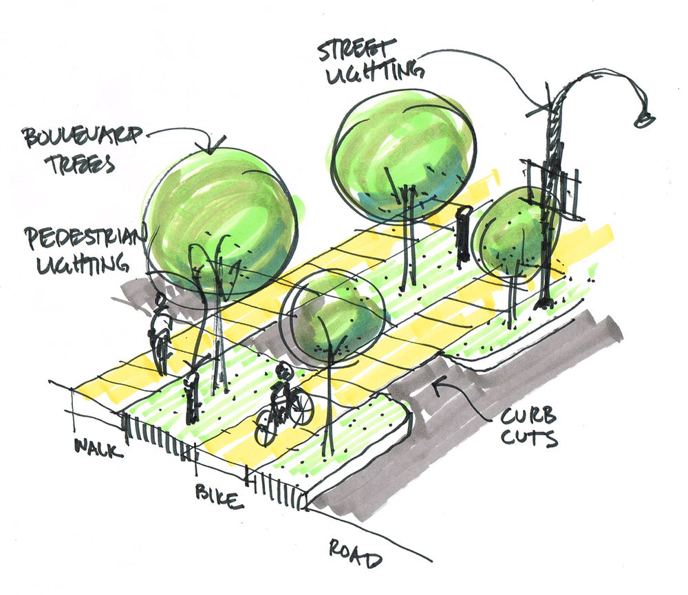
We need to go beyond bike lanes. Bike lanes and sharrows are great for avid bikers who feel comfortable rolling down the street next to 2,000 pound car separated by a 4" white line. Most people are not comfortable riding along or with motor traffic, especially in the urban core. They in turn spurn the roadway for the safety and grade separation of the sidewalk. This causes most pedestrians to feel uncomfortable as the sidewalk is not meant for bikers. Why not create a distinct bikeway, above grade from automobile traffic, and separated from the pedestrian sidewalk? A bikeway that, using the litmus test of writer Walker Angell, "is good enough for parents to allow their 8-year-old to ride a mile or two, by themselves, to school. Anything less may not be worth it."
To have great bikeways we need two important things: 1) a network, and 2) a welcoming destination. Arguably we have a network of bike trails, but where is our trailhead? Maybe this is an opportunity (in conjunction with the upcoming Soldiers Memorial Field Master Plan) to consider a downtown trailhead, just minutes from the front door of Mayo Clinic. Widening the pedestrian zone along 3rd and 4th Ave may be the first step in that process; establishing a stronger connection, enhancing the network, and creating two welcoming destinations (Soldiers Field to the south and Mayo Clinic's campus to the north). We need to go beyond just thinking striping satisfies the needs of bikers and create a distinct pedestrian zone.
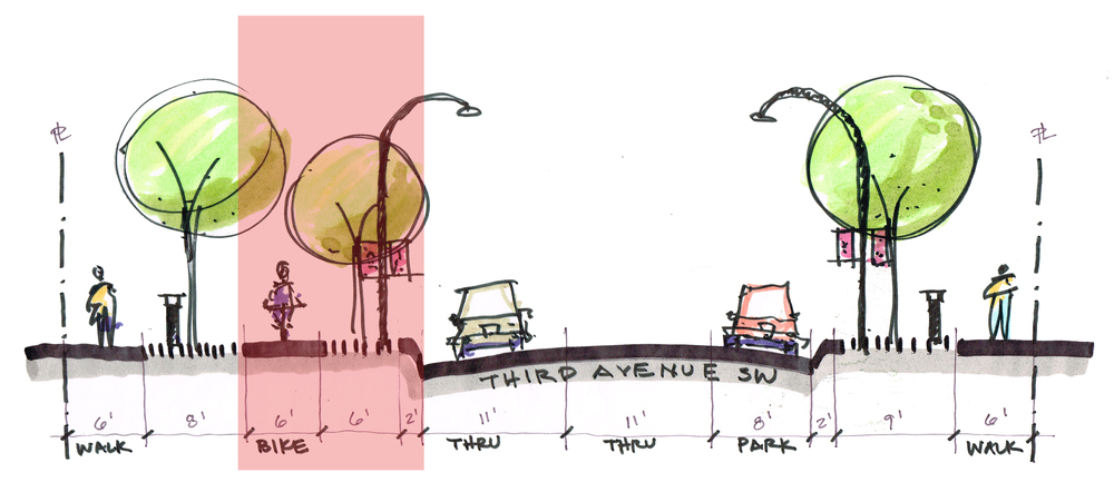
Sample Street Section (Mirrored on 4th Avenue SW)
The above street section modifies the existing R-O-W primarily in the red area. It swaps vehicular area for pedestrian area. This allows a second row of boulevard trees to be planted and a separate bikeway along with low level pedestrian lighting to make it welcoming also at nighttime. Furthermore the traffic lanes are reduced to 11' and on-street parking is maintained on the side where there are planned to be tall, multi-story buildings. Effectively it widens the narrow block between 3rd Avenue and 4th Avenue all the way from 4th Street SW to 6th Street SW.
As you progress southward the green space gets more substantial around 4th Street SW and continues all the way to Soldier's Field. Then at 6th Street SW there is an opportunity for a large scale paving change or mural in conjunction with an urban space to become the South Gateway for Mayo Clinic. South of 6th Street SW then continues to expand into green space and a re-oriented entrance into Soldier's Field made for biking and walking (as opposed to a parking lot entrance) makes this whole spine connect to the trails and thus could be a downtown trailhead.
Ultimately we are proposing an investment in the public realm that favors the pedestrian over the automobile. For this critical corridor there is a confluence of opportunities and funding including:
- Sales Tax funds for downtown improvements
- DMC funding for public projects
- Soldier's Memorial Field Master Plan
Also consider the effect that this public R-O-W change on the adjacent land use. As we have seen recently, when the street is reconstructed, there are protests by property owners for the assessments that are necessary. For this change, the assessments would be weighted toward the interior space between 3rd and 4th Avenue and signify that there should be a higher and better use for this land than speculative real estate holdings of single family homes. Thus over time driving out this vestige of a downtown long gone to be replaced by Mayo Clinic facilities which have long been held in the reach of their medical campus district.
By taking on this challenge, Rochester would be proactively embracing the ideals of DMC. It would set the stage for how we plan to develop our downtown and where the priorities lay. It will not happen without political and community support, so it needs to be a public and transparent process. And it needs true leadership. People willing to step outside of the comfort of conventional wisdom and popular opinion and embrace what is best for all of us going forward. Design Rochester is simply pushing the discussion; we want to be talking about it and we think you should too. Help us elevate this to a position of prominence and support a new era of a truly world-class healthy community.